Cape Fear and the Green Swamp
Click here to learn about CAMPING on the BEACH at Freeman Park.
 |
| I love this image created by artist Zeke Zilliox |
Cape Fear is a prominent feature on the east coast of North America. It is a headland that sticks out into the Atlantic Ocean. The Smith Island Complex of Bald Head Island (BHI), Middle Island, and Zeke's Island with their connective barrier beach and marshy back bay forms the cape at the mouth of a large river. Cape Fear is further shaped by the coming together of long shore currents creating 30 miles of Frying Pan Shoals. I could tell you a thousand stories about the natural beauty I saw growing up on the Cape Fear, but this time I’ll start with a story about a swamp. (Sorry, no camping in this post, I promise plenty of future posts about camping on the coast!) This post has tons of history and beautiful photos. (Most of which I do not own, but I tried to link to the source in the captions,)
Road Trip! Let's take a drive to the Cape Fear Coast. It's a trip I've taken a million times and traveled a thousand different ways. Our mom was originally from the Piedmont and our family moved from Southport to High Point in the mid 1980’s. We went back to the coast every summer. In those days the route was 220 to 211. It was two lanes, 55 miles per hour speed limit past the Uharrie’s and farmland of Randolph and Montgomery Counties.
 |
| Beautiful image by Will Stuart |
I loved the swamp!
I remember pressing my face to the window to look deep into the swamp searching for the glint of eyes looking out at us. There were stories of a swamp beast, and I wanted to believe. (Click HERE for a post about the Beast of Bladenboro.)
Even if there was no swamp thing, there were definitely alligators and giant bull frogs and snakes and who knew what other creatures. The swamp looked impenetrable, dark, and cool even on the brightest and hottest summer days.
 | |
| Cabin near Supply. Photo: David Cecelski |
I remember there were old mobile homes and little shacks every now and then on spots where the ground was a bit higher. No power lines or phone lines went to these places. I didn't even realize people lived in them till I was a little older and noticed clothes drying out on clothes lines, and fishing nets hung up on porches. I remember asking mama who lived there and she just said, “Indians.” “Like daddy?” I asked. My mom didn't answer..
On one particularly hot sticky trip through the swamp in our old Chevrolet station wagon with broken ac, the inevitable happened. About 40 miles from the coast, the car started overheating. Buzzers were going off, steam or smoke was coming out from under the hood, it smelled like burnt offerings and we were deep in the Green Swamp. This was a time before ubiquitous cell phones but even if we'd had them I doubt there's service to this day in the spot where our car decided to die. Mom started to pray out loud as she looked for a safe place to pull over.
 |
| Carnivorous plants in the swamp. |
Then we saw a sign. In the distance on the side of the road we could see a sign with a white cross on it. “A church!” we all said in unison. In the middle of the swamp there was a church. The sign said, “do unto others.” It was a Baptist Church with a funny name. We pulled into the empty parking lot. There were power lines and a phone line going into the church. I tried the doors. All locked. No one was there. The sun was setting. I sat on the curb with Sugarbabe and started to cry, I was sure we’d be spending a sweaty night in the car there in that swamp church parking lot. Mosquitoes bit my skinny legs.
 |
| Brunswick County Cypress |
Somewhere close by bullfrogs croaked loudly back and forth at each other. I looked out into the dark of the wilderness. Something caught my eye. I held my breath, squinting into the dark. It was just lightning bugs. The shine of headlights and the sound of an old truck startled me back to the reality of the parking lot.
Two men jumped out with flashlights, one had a tool bag. “We saw ya with yore hood up and went home to get light. What seems to be the problem?” He was already looking under the hood. “Oh dear.” he said, “Looks bad, did you overheat? Yore head gasket looks busted.” The other man said, “I radioed preacher, he's comin to let ya in, the church is the only phone round here for a ways.” About then a Cadillac pulled in and an older man and woman got out. He unlocked the church and she led us inside, even let us bring in the dog and got her a bowl of water. The church was small and had green indoor outdoor carpet from the wheelchair ramp outside all the way through the sanctuary straight up to the altar. That’s when I noticed it. A giant dream catcher hanging on the cross, Indians. Like daddy. The preacher’s wife gave us lemonade and church cookies, while the grown ups discussed things and looked under the hood. The car was officially dead, for the night at least. The preacher called his brother, a mechanic, and he agreed to come get it with the tow truck and fix it up first thing in the morning. The preacher's wife called her sister who managed a hotel in the closest town. They got us a room, we could even take Sugarbabe. In the air conditioned back of the caddie, crammed in with my sister, mom, and giant dog I was cooler than I'd been all summer.
The next morning I walked outside and was blinded by the sun reflecting off the bright green of a field of tobacco. I could smell it, strong on the warm breeze. Our car was already fixed and sitting in a parking spot right in front of our room. There was a note that said we owed them nothing for the repair or the room, that the Creator had provided for our safe travel. The swamp never smelled as sweet as that morning, looking out the car window I could see steam rising at the base of the ancient trees.
Two men jumped out with flashlights, one had a tool bag. “We saw ya with yore hood up and went home to get light. What seems to be the problem?” He was already looking under the hood. “Oh dear.” he said, “Looks bad, did you overheat? Yore head gasket looks busted.” The other man said, “I radioed preacher, he's comin to let ya in, the church is the only phone round here for a ways.” About then a Cadillac pulled in and an older man and woman got out. He unlocked the church and she led us inside, even let us bring in the dog and got her a bowl of water. The church was small and had green indoor outdoor carpet from the wheelchair ramp outside all the way through the sanctuary straight up to the altar. That’s when I noticed it. A giant dream catcher hanging on the cross, Indians. Like daddy. The preacher’s wife gave us lemonade and church cookies, while the grown ups discussed things and looked under the hood. The car was officially dead, for the night at least. The preacher called his brother, a mechanic, and he agreed to come get it with the tow truck and fix it up first thing in the morning. The preacher's wife called her sister who managed a hotel in the closest town. They got us a room, we could even take Sugarbabe. In the air conditioned back of the caddie, crammed in with my sister, mom, and giant dog I was cooler than I'd been all summer.
 |
| Stock image |
 |
| Photo from Nature Conservancy |
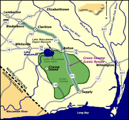
The Nature Conservancy’s website is a great source for up to date information on trail conditions, they maintain 17,424 acres of long-leaf pine savannas and bogs in the Green Swamp. The trail head is off of 211. Southeast of 74, northwest of 17, in Brunswick county.
“The Green Swamp contains at least 14 different species of insectivorous plants, including extensive populations of Venus flytrap, sundew, butterworts and bladderworts, and four species of pitcher plant. The preserve is also home to many rare animals, including the American alligator, Henslow's sparrow, Bachman's sparrow, and Hessel's hairstreak butterfly.”

 |
| Photo from flickr |
 |
| Giovanni da Verrazzano |
Just two years later the Spanish, who had established colonies to the south, landed at Cape Fear and attempted a short lived settlement. The Spanish continued to attempt northern expansion of their interests and failed repeatedly as they encountered struggles navigating the dangerous capes, faced resistance from the native people, and found traversing the swamps impossible.
 |
| Richard Grenville |
The English had successfully established a colony in Virginia in 1606. They established a strong hold on the northeast, with the colonies of Maine, Plymouth, New Hampshire, Salem, Massachusetts Bay, New Scotland, Connecticut, New Haven, Maryland, and Rhode Island and Providence.
 |
| Irish Terror |
 |
| NCPedia |
Coastal plantations were benefiting from trade with England, as small subsistence farms dotted the land to the west. Acquiring slaves and participating in trade was difficult for inland farmers because of the vast swampy wilderness between them and the coast. There were political and social tensions between farmers and planters. The Lord Proprietors encouraged participation in the English mercantile system and slave trade. Plantations eventually spread out across the area, growing sweet potatoes, peanuts, indigo, rice, and tobacco.
Thomas Smith was granted the land around the cape in 1713, which included soon to be Smith Island (Bald Head Island) and Smithville (Southport). The following year, Thomas James was granted 1000 acres west of the Cape Fear River.
 |
| Stede Bonnet |
In 1725, more land in the area was granted to Maurice Moore, Samuel Swann, Charles Harrison, and Eleazar Allen. Moore, a second generation planter who had defeated the Cape Fear Indians in battle, founded Brunswick Town in 1726 on the river just inland. (Just have to add that obviously the 'Cape Fear Indians' had a tribal identity not shaped by a white mans fear of dying shipwrecked on the coast he was 'conquering'.) In 1732 the town that would become Wilmington was founded further inland on the river. Near Brunswick Town in 1735 Moore built Orton plantation and began growing rice there.

As global trade increased, the need for lumber and tar for boats increased, and interest in the vast Carolina wilderness increased. In 1735 the swamps were explored by popular naturalist William Bartram who published a book about his travels through the south. Soon the area began attracting development. The rivers became routes for the export of trees to the naval yards.
In 1745 Spanish privateers were increasing attacks on English interests and a fort was built at the mouth of the Cape Fear River, Fort Johnston.
Revolution against the British, technically began in 1776, but the war raged on for seven years. One of the last Revolutionary War campaigns in North Carolina was the Wilmington Campaign of 1781.
Brunswick Town did not survive the revolution, though Orton plantation did and its owners eventually bought the land that had been Brunswick Town for pocket change.
In 1792 the town of Smithville grew at the mouth of the Cape Fear River around Fort Johnston. The town was named after revolutionary war colonel, area planter, and eventual governor, Benjamin Smith. In 1795 Benjamin Rowell sold 25,000 acres of swampland west of Smithville to Smith for '2,000 pounds'.
In 1797, the state sold close to two hundred thousand acres of the Green Swamp to planters Stephen Williams, Benjamin Rowell and William Collins for around $7,000. Some of the land was ditched and drained for farming.
 In 1802 the senate first made a proposal for an Intercoastal Waterway (ICW) on the east coast from the Gulf of Mexico to Boston. The Great Dismal Swamp Canal on the VA/NC border opened in 1805, while the Army Corp of Engineers (ACOE) began work on other sections in 1824 with a goal of making the coastline more navigable.
During the Civil War blockade runners defended the people and supported the struggling economies of the port and river towns. Many inland towns were battlefields. The thick swamps protected others from the wrath of Union soldiers. The tribes in the swamps and along the rivers welcomed runaway or freed slaves into their communities. A fort was built north of Cape Fear at the New Inlet. Fort Fisher, Fort Johnston, and Fort Caswell defended the area from the Union Army. Wilmington was one of a very few southern cities to escape destruction.
During reconstruction, carpetbagging northern industrialists treated the south as the spoils of war. Owners of paper mills recognized the potential of the quick growing pines in the savannas and began buying acreage in the late 1800's.
The Jim Crow era brought tense race relations. The white supremacy movement was angered by the success of freed slaves and other free people of color and began promoting discord between native populations and free slave populations. They also moved within political circles to create laws hindering non whites. People of color and poor whites in the coastal area were violently forcibly removed from the centers of commerce and positions of power. Under Jim Crow a separate second class developed in the south and created an economy of fishing and subsistence farming.


From 1929 to 1932 the ACOE completed a channel that cut across the Cape connecting the river and the Myrtle Grove Sound which has an inlet to the Atlantic. Snows Cut was named after the ACOE Major in charge of the project. The channel was span with a wooden drawbridge until 1931, then a steel swing bridge, which was replaced with the current high rise concrete structure in 1962.
 |
| Click here to learn more about the Dow ruins |
In 1951, Sunny Point Military terminal became official as the largest east coast location for the transport and storage of munitions just across the river from the Dow site.

Another wave of people moved to the coast as the spread of air conditioning made life in the humid swampland more hospitable. The post war era in American was marked with massive economic growth and a pop culture boom. 1960's Hollywood helped spur a global fascination with surfer beach culture, sending families and teenage boomers to the coast in droves. Real estate development of coastal areas became extremely lucrative.
Some marshland on the west sides of the sandy barrier islands was canaled to create rows of vacation homes with dock access. Frank Sherrill had a development plan in place to fill and dredge thousands of acres of wetland and marsh on Smith island for development of a modern resort. There was to be high rise hotels, shopping, amusement rides, and a replica pirate ship in Buzzard Bay.
 |
| Ocean Isle |
Environmentalists discovered what the first explorers noted: that the cape fear area of NC was home to a complex range of flora and fauna. It was the boundary line between the temperate zone and the subtropical zone. There is some biology there that doesn’t exist anywhere else in the world, like the Venus flytrap. Fights between developers and environmentalists made the papers.
 Preservation of the area began in 1969 when 761 acres of cypress swamp, old growth live oak and long leaf pines stands, and bogs full of carnivorous plants, along the Cape Fear River was preserved as Carolina Beach State Park. (Future post about camping there.) The area around the Green Swamp which was owned by paper producers was designated a national natural treasure. Smith Island was bought by Carolina Cape Fear Corporation, a group of outdoors-men from the Piedmont who planned responsible development and immediately gave 12,000 acres to the state for preservation, managed today by the Bald Head Island Conservancy and the North Carolina Nature Conservancy. (I could write a book about BHI, but I'll save the stories of that amazing island for future blog posts.)
 By the late 1970's environmentalists had created global awareness about the dangers of deforestation, promoting recycling, and painting the paper industry as wasteful tree killers. The companies rushed to save face. The Federal Paper Board donated their swampland to the state, creating the Green Swamp Preserve. 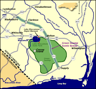 Today, 14,000 acres of land is protected, maintained by the Nature Conservancy, and they maintain trails where visitors can walk through the bogs and the savannas and observe the rare bug eating plants and if lucky the even scarier snapping jaws of the American alligator.
The trails are currently open, and social distancing is required.


No comments:
Post a Comment