What it's all about...

Exploring Natural Places in the Southeastern United States, Uncovering Hidden Histories, and Examining Local Mysteries
Showing posts with label humor. Show all posts

Thursday, September 24, 2020

The Truth about the Carolina Shag

The Carolina Shag

A story about the end of segregation.


The geographic origins of the Carolina Shag are obvious by it's name, but it's history is more of a mystery to most people.


You may not even know what the Carolina Shag is if you're not from the east coast. Perhaps you can think of pop culture references to the dance. In 1997 the country music band Alabama had a hit song called, "Dancin', Shaggin' on the Boulevard". The song, written by Randy Owen, Teddy Gentry and Greg Fowler, peaked at No. 3 on the Billboard magazine Hot Country Singles & Tracks chart. It was about the band's early days playing beach music in Myrtle Beach, SC at bars on Ocean Boulevard. 


You might think of the dances in the musical "Hairspray". This campy musical is actually a good hint to the truthful history of the Shag. The musical is set in 1962, following a "pleasantly plump" teenage girl named Tracy Turnblad. She is pursuing stardom as a dancer on a local TV dance show. The tension in the plot is due to her anti segregation views. She danced at places that were for nonwhite people and rallied against racial segregation, because the dance moves that made her popular had come from people of color she'd been dancing with.

The Shag originates in the Jim Crow segregated south. Historians say the term shag was coined at Carolina Beach, NC. It wasn't always called that. The dance was popular from Wilmington, NC down to Georgetown, SC. White people doing swing dances like the jitterbug started calling a dance they were doing the Carolina Jitterbug. The name they had been using before that paid homage to its true origins; the Little Apple was the white version of a dance called the Big Apple. Called little because white dancers performed a less flamboyant version of the dance. The Big Apple got its name from a SC club for people of color in the 1930's where the dance originated. Fictional Tracy Turnblad wasn't the only white person "jumping the Jim Crow rope" and going to the segregated clubs.


Dancers on the coast popularized the Shag just as segregation was coming to an end. Beach music, which was heavily influenced by the blues, became popular on commercial radio as baby boomer teenagers wanted something they could swing dance to. Beach music bands of all races were played on the radio and allowed to perform for mixed audiences. The popularity of beach music was pivotal in a wider acceptance of music from musicians of color. The musicians who'd developed their beach music in the segregated clubs also played Rhythm and Blues. White musicians began covering the R&B songs from musicians of color. This, as we all know, led to the invention of Rock and Roll. Today 'cultural appropriation' is a hot button topic but it's nothing new. Eminem rapped about it in the 2002 song  'Without Me.'  

"Though I'm not the first king of controversy, I am the worst thing since Elvis Presley, to do black music so selfishly, and use it to get myself wealthy."


If you listen to popular music today you can't escape the influence of the Carolina Shag. From hip hop to pop country, dance music still breaks down racial barriers. That next dance craze the kids are into might even spur a revolution, you never know.

Wednesday, September 9, 2020

Did the Nazi's bomb North Carolina?

 Dow Chemical Plant Ruins


Warning: Government property, no trespassing, area patrolled by military police!


Location: Dow Roads Woods along the Cape Fear River on 'Pleasure Island' 

 
Original Purpose: In 1934 Dow Chemical began extracting bromine from salt water.


There's tales of spirits and spooks and creepy creatures all through the Cape Fear region, but the woods on the west side of Pleasure Island seem to have something extra that makes them magic.


The Cemetery

On Dow Road somewhere between Carolina Beach and Kure Beach 'Alice' and her friend parked in a sandy parking area with a wooden sign for Federal Point Methodist Church Cemetery. No cemetery was visible from the road, all they could see was a mossy, sandy path into the dark woods. There was a large yellow barrier blocking any vehicle traffic, which anyone wanting to mourn at the cemetery would need to go over, under, or around. The temperature seemed cooler as soon as they began walking the path. The air smelled of earth. Something ran off through the woods as they approached. It was big. They decided it was a dear.  The first signs of the cemetery became visible, the girls see a cracked concrete table sitting crooked in the sand and a rusted and damaged chain link fence. They slowed and became skeptical. They were looking for a historic site. They saw newer tombstones adorned with shabby fake flowers and tattered miniature flags. It was not well taken care of but it didn't seem historic. Disappointment was adding to the gloom of the day. It began to sprinkle and the girls were just about to go back to there car when they saw it. Just to the back of the modern cemetery was a historic plaque, they ran towards it. Alice tripped over an exposed root but landed in the sand with some amount of laughter. They joked about horror movie cliches. 

The girls started googling on their phones. The Newton Home site and Graveyard at Federal Point is the oldest archaeological home site of Europeans on North Carolina's islands. Artifacts dating from the 1700's and 1800's have been found there. The graveyard contains markers with well known local names of early settling families. Many tombstones are missing or destroyed. The graveyard is surrounded by woods. The oral history of the area says there was a grave site for people of color as well, today it remains unmarked. 

There is a doghouse sized replica of one of the structures that burned in a fire that destroyed buildings and took lives in the early settlement.
Beside the chain link fence between the modern cemetery an the historic one are two graves decorated in seashells and coins and other strange collected things. They are paupers' graves. Donated to those who had no means for a burial. One was a vagabond who ended up in the area and was well loved by the community and the other was a legend, The Fort Fisher Hermit, a man who'd lived on the island in the middle of the 1900's alone as a hermit. People would pilgrimage to meet with him and hear his philosophical take on the perils of the modern world. (Click HERE for a post on the Hermit) From the back of the old grave yard there is a sandy path going off into the woods. Knowing the river was nearby, the girls decided to follow the path hoping it would lead to the water. It was still sprinkling every now and then but it was warm and not to much of a bother. The moisture increased the smell of earth in the air.


The River

The girls saw the sunlight before they saw the water. It was shining still to the west. They came to a clearing and saw that they were on a bluff above the river bank. It was about four or five feet and sandy so they jumped down the embankment. The sun was shining off the river. There was a little beach there and they walked along it taking in the sun and beautiful scenery. No other humans anywhere to be seen. 
It was so beautiful they got a little carried away and walked a long ways down the beach. Taking pictures of the river and the trees along its shore. They walked along for sometime until they came to a place where they could not go any further. There was an old structure, rusted metal and wooded pilings. It was a retaining wall of some kind. Alice climbed atop and announced that there was water, black and deep on the other side. It was not cross able. There was smoke on the horizon across the water. The girls used Google maps to see what was there. Sunny Point Military Terminal. They joked about the men in black. They Googled some more. Dow Chemical. They had heard of the ruins in the woods and the legend of how they came to be. They scurried up the ridge to see if they could see anything else. Nothing but dark woods, the smell of earth, and rustling of some small animal in the underbrush. 
More Google.


Into the Woods

They found a picture of the old site. Dow had chosen it because a nearby Carolina Bay made a perfect natural holding reservoir and there was already a trench that had been dug during the Civil War as part of the defenses along the Cape Fear. Using the picture of the old site they decided they'd need to venture into the woods a bit and try to find a way around or over the trench. The woods were dark and dense. The smell again was strong. Earth. Enough smell of earth in the air to almost choke a person. Alice swore she saw a dog. Her friend wondered if it was a coyote. They went into the woods anyway. They were on an adventure and they were determined.
They peered out into the forest, looking for any signs of structures or creatures like the big cats they'd heard prowled these woods. Reassuring each other that it was just legend. Something caught Alice's eye. She tried to use her phone's camera to see what it was without going closer. The picture didn't really help. They decided to cautiously approach. As they got closer they could smell the odor of death. It was a bird. A large bird. To their surprise it was a hawk. It was hanging from an odd low limb of a tree. It had the claws of one foot deep into the wood. Nothing about its position in the woods looked natural. This beautiful bird hanging there to decay and be eaten. Needless to say the creep factor was rising. The rain started back. 


The girls were not going to give up. They went deeper into the woods following along the trench. 
That's when Alice screamed. A pile of bones were in the path and off to the side was a skull!

The bones were real but the skull, thankfully was a cheap plastic Halloween decoration. It wasn't even close to Halloween. The girls had theories about what they had come across. Maybe it was a ritual of some kind. Witchcraft. Maybe it was just the killing field of a predator animal and the skull was dragged there by mistake. Whatever it was they had finally found the way across the trench just past the bones. It was like a land bridge across the trench. Once across the girls saw thick woods and something colorful. It was their first glance at the graffiti that adorns the ruins. 

The Dow Chemical Plant Ruins


The ruins have long been a popular spot for mountain bikers and graffiti artists and any other youngster looking for a slightly illegal way to pass the time. The remnants of the buildings are brick and concrete. There are concrete footings and tunnels and a towering pile of brick rubble. 

The girls walked through the tunnels. It was surprisingly colorful. Graffiti covers everything and some mischievous people have created a fairy land with pink and green fiberglass and plastic wands over a bed of bricks, broken and splattered with red paint. The wall above scrawled with a plea to jump in, lay down and get comfy. It started raining harder and the girls sat in one of the tunnels listening to the silence and the rain. 
More time to Google. What exactly did they make here? Bromine, used for photography and chemical warfare!? What happened to this place? Officially: It was decommissioned in 1946 when a plant opened in Texas. But ask a local and you might hear the legend about what happened there during WWII. There is very little information about the chemical plant during the war years and the decommissioning and destruction of the structure isn't well documented. A media black out surrounding certain events led to the wide spread belief that there had been a cover up. Locals say that at the end of the war the Nazi's desperate to stop production of chemical agents drove a submarine up the Cape Fear to the site of the chemical plant and fired on the structure, damaging it beyond repair. The area became a part of the Sunny Point Military Terminal's buffer zone after the war. An area protected and patrolled by the military to insure security and safety surrounding the nations largest marine terminal for munitions. Any person wanting to see the ruins for themselves does so at some risk. There are wild animals of course, and there could be some sketchy people, as well as the military police on atv's and carrying guns. There are also bugs. Lots of bugs. Mosquitoes are everywhere because the ruins have a lot of standing water in low spots. People have come out of these woods covered in hundreds of baby ticks, like specks of dirt crawling up their legs. In the summer there are spiders that build giant webs across the trail at face height, they can be as large as a human hand. This is not a place for the weak or easily frightened. 


Saturday, September 5, 2020

Go with the Flow

Following North Carolina's Groundwater 

From the Mountains to the Coast

(Stopping in my back yard to check out my town and the local campground.)

Boone, NC
    In North Carolina the flow of groundwater is kind of complicated. Water moves from areas in the mountains, like the Appalachian temperate rain forest, through a layer of weathered rock and soil, called the regolith, into cracks in the crystalline bedrock to the aquifer underneath. The water flows through the fractures and emerges as springs and streams in the lower elevations.
NC rivers 1830

 The creeks and rivers flow through the Piedmont Plateau picking up sediment, eventually crossing into the Coastal Plane at what is called the fall line, where the hard bedrock of the Piedmont shifts to the softer coastal formation and the rivers have rapids and waterfalls.The rivers pick up more sediment as they travel through the permeable sand hills and swamps, eventually depositing this sediment to help form NC’s distinct coast line. Groundwater in the Coastal region is absorbed from creeks, rivers, and swamps. The interaction with the ocean has created a complex freshwater-saltwater transition within the coastal aquifers.

    I’ve written about the Cape Fear region a couple of times. And I have mentioned how the Cape Fear River has its beginnings far from the coast. In fact, the Cape Fear is a great example of how NC’s watersheds work. The Cape Fear river begins in Haywood, close to the Chatham and Lee county line where the Deep River meets the Haw just south of its exit from Jordan Lake. These are rivers that begin with springs in the Piedmont. The area where these rivers begin has head springs which feed many rivers. There are megacrystic features and intrusions of granite from the Paleozoic Era, what that means in plain English is that the terrain in this area has cracks or veins in the rock bed where past geological events like earthquakes, volcanoes, or other plate movement pushed large crystalline rocks and older granite up into the younger bedrock. These intrusions give groundwater a flow path both to and from the aquifer and thus many springs can be found in areas with this type of unique geology. 
    The Deep River actually has multiple head springs, the East Fork of the Deep River begins in the Sandy Ridge area near the runway of the Piedmont Triad International Airport. The West Fork begins in Kernersville near the intersection of two major highways. (Runoff mitigation has been a continuing issue at these headwaters.) The West Fork flows south to High Point where it feeds the man made Oak Hollow Lake (where I live). It exists Oak Hollow at a controlled dam and flows across the northeast side of High Point into City Lake. The East Fork flows from Sandy Ridge through northeastern High Point and then into City Lake. The two become one as they exit this lake headed southeast. The river leaves Guilford County near Jamestown where it heads through Kersey Valley into Randleman Lake Reservoir. From there the river flows south through Randolph county from Randleman northeast of Asheboro. It winds eastward to Franklinville, then at Ramseur it heads south until High Falls where the river moves west and northwest along the fall line. 
    The region where the river runs in a counter intuitive direction is significant geologically, not just because of the fall line. The Deep River coal field is an area of Triassic rocks stretching 36 miles along the river in Chatham, Lee, and Moore Counties. In the age of dinosaurs there was a vast swamp along an ancient river. As swamps tend to do, decaying plant matter formed layers of peat in the humid dense environment. Over huge amounts of time shifts in plates and other events changed the landscape and large amounts of sediment flowed down and gathered in the area where the river turns. The pressure of the massive layers of sediment created the perfect situation to turn the peat into coal. For 200 years people have attempted to dig this coal out of the ground. Deep River is NC’s only commercial coal bed. The coal industry is extremely dangerous and many tragedies are associated with mines. Over time the abundance of illness, death, and mishap creates a need for explanation in the human mind. As we often do, people created legends to place blame somewhere that would give them the opportunity to feel like they could continue working and create superstitious ways to protect themselves. It was a way to rationalize a terrible industrial human rights travesty without placing blame on the industrialists. In NC's coal mines, it came in the form of a demon. The Deep River coal field is cursed by this disturbed demon, and many have lost their lives in his clutches.
    As the river leaves the coal fields and drops onto the flatter plain to the east of the fall line, just north of Sanford. Southeast of Pittsboro, it joins the Haw River, just below the Haw's emergence from Jordan Lake.

Mermaid Point
     The area where the two rivers converge to form the Cape Fear River is called Mermaid Point. Legend says that mermaids would swim up the Cape Fear River from its mouth seeking the fresh water source. (Click HERE for more on Mermaids of the Cape Fear)
    
    Of course, Native Americans lived along the river for thousands of years. Europeans were settling in the Deep River basin from the Virginia or Pennsylvania colonies during the 1700's. The town I live in developed later with industrialization and improvements in transportation. First in the area was James Mendenhall, a Quaker like many who were moving to the area, received a land grant in 1762 in the place that is still called Jamestown. He built a gristmill and a sawmill on the river.
Mendenhall Home
His heirs built a home and by the 1800's the Jamestown Quaker’s had a thriving community. However, in 1851 the North Carolina Railroad built its tracks to the south of Jamestown instead of through it. The placement of the railroad was hotly debated at the time. It’s location would be a boom for whatever community was closest. At the railroad’s highest point it intersected NC’s Great Plank Road. This intersection was incorporated in 1859, becoming High Point. The area's location was ideal for trade because of the transportation hub. People in the area grew tobacco, cotton, and produced furniture from the vast hard wood forests of the western Piedmont and foothills.

High Point, 1913
By 1889 High Point had its first furniture factory. In the next ten years thirteen more furniture factories and a handful of textile mills turned High Point into a bustling industrial town. In 1905 NC held its first furniture exposition, the Southern Furniture Exposition Building was built in 1921. It was ten floors and 249,000 square feet. Throughout the 1920’s the furniture industry continued to grow, as did High Point. The city purchased the land that had been the original Mendenhall site along the river, and tore down all the structures.

They built a dam to create City Lake, a reservoir for drinking water as well as recreation. City Lake Park has a number of amenities; a large swimming pool with a water slide, grills, picnic tables, shelters, a merry-go-round, miniature golf, and the 340-acre lake. Of course my memories from childhood are of the miniature train that goes around for taking in scenic views of the lake. Also back then there was an old fire truck that kids could play on.

I love kitchy roadside stops and furniture city has a few. High Point chamber of commerce built the world's largest chest of drawers in 1926 to showcase the towns industries, furniture and textiles. Neighboring Thomasville, not to be out done, created the world's largest chair.  The chair has been re-titled, the largest Duncan Phyfe Chair, after the famous man who designed the chair and many others. 
    The Piedmont is home to the original Krispi Kreme Doughnut shops and though the store on main street has been rebuilt to modern standards, they have kept the vintage neon sign. 
    
    Oak Hollow Lake, High Point, NC is a relatively new man-made lake. The dam on the West Fork or West Prong of the Deep River was completed in 1971. A larger water source and recreation facility for a booming international city. High Point was becoming a global center for furniture sales and manufacturing. Of course the 1980's and 90's deregulation of global trade led to deals with countries where labor and natural resources were cheaper. Many manufacturers moved plants to other countries. This changed the economic outlook for towns like High Point. No longer booming much of High Point's growth today is centered around the University, though furniture market is still the main economic driver. 

Oak Hollow Lake happens to be my back yard. Well almost. There is a campground, a marina, a playground, and picnic areas just a short drive down the street. I had never really utilized this beautiful place until recently. Last spring I started taking the kids I babysit to the lake side playground. It is beautiful. I hope to plan a camping trip to one of their lakeside spots as our first attempt at camping with the baby. (Safely less than a mile from home.)  I will post about it for sure!


Friday, August 28, 2020

Freeman Park Carolina Beach, NC

"The North End" 

Writing about cold weather camping with my mom reminded me of another cold weather camping trip years ago. I spent New Year's Eve ringing in 2009 camping at Carolina Beach, Freeman Park. The cold chill was well below freezing. 


    It was cold. But when you are prepared for cold weather camping you can have a blast! My friend Stephanie was in grad school for geology so we were camping with a group of earth scientists which turned out to be great. I didn't have to do anything, not the tent, not the fire, not the food, I just dressed warm, cuddled with my dog Daisy, and hung out around the fire. It was in the teens that night. I wore thick leggings under wool pants, a tank top, a thermal, a hoodie, and a leather jacket. I slept good and woke in time to see the sunrise. 
    When I first went to college at UNCW in 1999, it was just called 'the north end', there was no fee or access pass, and it was a huge four wheel drive beach with vast stretches of dunes and low brush and bramble woods of wind strained cedar running right up to the muddy marsh. I still lived on campus the first time I camped out there with a group of friends from the dorms, their boyfriends had big four wheel drive trucks and thought they'd show off. The little guy driving a Z71 with huge 44 inch super swamper mud tires hauled off down the end of the beach toward the inlet. He thought the low tide revealed sand flats he could cut a doughnut on. He was wrong. It was marsh mud, apparently more than 44 inches of it because he quickly buried those tires, throwing up huge clods of mud into the air. He was good and stuck. The girl from the dorm in the truck was a pretty Italian girl, and definitely the most high maintenance of all the girls in the group. She was the only one that would be upset about some mud. At first she refused to get out of the cab. Then she climbed out her window and onto the roof. She inspected her surroundings. She decided she could jump to the sand. She was wrong, mud up to her knees, past the hem of her cute little capris, swallowing one rainbow flip-flop and a toe ring as she screamed and kerplunked her way out of the mud in giant strides. Needless to say over the years we all got better at navigating the ever changing terrain of the area around the inlet. There used to be a back road through the bushes by the marsh, but it got muddier and the marsh got closer and eventually there was water where the trail had been. The beach has changed a lot over the years, and has suffered from extensive erosion. Currently there are restrictions on camping and vehicle access due to erosion.
   
From Wikipedia
I've written about the Cape Fear River area and how meaningful it is to me, like a geographic connective tissue for my family. Mom is from High Point, where the Deep River begins, it and the Haw river come together as they leave the Piedmont to form the Cape Fear which then meanders through the swamps and Carolina Bays of southeastern NC as a black water river which empties into the Atlantic to help create the headland of Cape Fear. The town at the mouth of the river, Southport, is my father's hometown. The region's geography, a cape which sticks out into the warm waters of the gulf stream, has created an incredible ecosystem with vast beaches, large dune ridges, dense maritime forests, deep swamps, long leaf pine savannas, brackish creeks, and marshes. The area on the east side of the river, south of Wilmington all the way to Fort Fisher, was called Federal Point, Cape Fear being the lower Smith Island Complex. 

    For thousands of years native people flourished in this region. Artifacts show prehistoric big game hunters that eventually settled in the area so rich in flora and fauna. Prior to the European invasion the civilization that existed was hunting as well as farming vegetables and tobacco.  
   
     I've written about the early attempts at 'settlement' by the invading Spanish, and then the eventual successful invasion by the English, with their establishment of Lord Proprietors and the plantation system which was built around an inhuman mercantile system that monetized and objectified actual human beings, as if they were farm animals or equipment. We've talked about the tribes of the swamps taking in freed or run away slaves. I have also written about Jim Crow and the affects of racial segregation. I've mentioned the separate economy on the coast, driven by seafood. The disgusting beginnings of our country can't be ignored, they shaped who we are today. The 'north end' of Carolina Beach is now called Freeman Park, a name that tells us something about its history. 
  
The mythology around the area says that a freed slave took his 40 acres and a mule sold and invested and eventually purchased land from Myrtle Grove to the river, in what was called Federal Point, part of the Cape Fear peninsula. The truth is Alexander Freeman purchased the land in 1876. There was a lovely bluff over a sound, old growth hard woods, marsh, and salt flats, and 300 acres of beach front. Alexander was a 'Free Person of Color', which legend has conflated into him being a freed slave, though some of his ancestors may have been, his father Abraham is also listed as a 'FPOC' and was a land owner through grants from the Lord Proprietors. Alexander was black and American Indian and lived from 1788 to 1855. His current living decedents are members of the Waccamaw-Siouan and Lumbee tribes. 
    One of Alexander's sons, Archie, had a place at the beach where they served up fresh fried seafood. Alexander gave the land to Robert Bruce Freeman, who died in 1902, giving it to his children. It was that generation who built the first houses in Seabreeze and cleared a road through the woods to Myrtle Sound. In the 1900's  Ellis Freeman also had a seafood place. 
    At times segregation laws got so strict that only whites were allowed access to Carolina Beach from the main land and people of color that wished to enjoy the north end of the beach had to swim or wade across the Myrtle Sound. Banks were unregulated and often allowed to take advantage of people, obtaining land deeds under shady circumstances. Some of the Freeman family lost portions of their land to the banks during this time. Then the government used eminent domain to obtain the land they needed to connect Myrtle Sound and the Cape Fear River. After the construction of Snow's Cut, the current and depth increased so that the only way across was by boat. (Hundreds of acres of Freeman land were eroded by the new waterway.) Eventually people of color were allowed to cross the bridge, but only on Monday's. Then laws changed so that they could cross 'normally' as long as they wore clothes over their bathing attire and went straight to 'their beach'. The first hotel came in 1924. 
    During the segregated Jim Crow era, people of color came to Seabreeze, from all around to enjoy the shade of the trees, the breeze over the water, the big stretch of beach, and the seafood. They also came to dance. In 1951 Lula Freeman Hill and her husband Frank built a place for dancin' and then they built a hotel.

    Bop City and the Monte Carlo By the Sea became the center of a resort where people of color went to see and be seen. When black musicians would come to Wilmington to perform they would stay at the Monte Carlo. At it's peak there were over 30 places to dance. 

 
People in the Carolinas will often tell you that Carolina Beach and Myrtle Beach are where the dance 'the shag' originated. The truth, as with most history is a little more complicated. During Jim Crow segregation the communities of working class whites and people of color were often geographically close and despite the restrictive laws separating people in public spaces, some white people enjoyed going to dance clubs that were for people of color. In clubs along the Carolina coast, like Bop City, people were doing a dance called 'the Big Apple', and white people copied it, as best they could, and called it 'the little apple'. That dance became 'the shag'. (add to the list of things stolen from people of color)
    I grew up hearing horror stories about the worst storm to hit our coast, Hurricane Hazel hit on October 15, 1954, killing 95 Americans. Most everything directly on the coast was destroyed. I remember the islands in the area where I grew up had plaques on certain structures designating them as some of the handful that had survived. There were signs showing the high water mark of the 18 foot storm surge. 
    Seabreeze was a victim of the storm and the changing times. Many of the businesses, including Bop City and the Monte Carlo, were destroyed, those that weren't closed up because the destruction around them made the island much less appealing. The era of segregated public space was ending and Seabreeze went with it. 

    When I moved off of campus in 2000, I moved to Monkey Junction, near Myrtle Grove. I'd always remembered the story about Monkey Junction I'd been told as a kid. The area is nothing more than a large intersection in the northern part of Federal Point, where several main routes to travel down the Cape Fear Peninsula come together into one main road going down the middle straight to the bridge over Snow's Cut. If you were going to the island from downtown Wilmington you came up along the river on river road or Carolina Beach Road, and if you were coming from mid town or any town west of Wilmington you most likely came straight down the middle on College Rd, and if you lived somewhere along the coast and marshes towards Wrightsville, you road the winding path through Masonboro woods and Myrtle Grove. The two roads on either side keep going along the edges of the river and the waterway until they eventually turn in to the middle just before the bridge, but if you wanted to get food, or bait, or beer before the island Monkey Junction was the place. 

There was even a shady roadside zoo that started with just a handful of animals by a WWII vet in the '50s. Originally showcasing his collection of masks, shrunken heads, and spear points from the South Pacific. The zoo was the thing that always reminded me of the origin story. The area had long been a stop for people heading down the peninsula to the coast for pleasure or for military purposes. The locals, looking for ways to make an extra buck, sold seashells, turtles, sharks teeth, hermit crabs, gator skulls, and Venus flytraps at roadside souvenir stands. One stop that sold gifts as well as bait, seafood, gas, and groceries, decided to entertain their customers with the presence of a tamed monkey or two. The story I heard was that kids would stop and eat ice cream and squeal at the monkey dressed in a diaper and kept in a cage. 
  By my college years Seabreeze was a not much more than a sandy old road that looped around to the waterway where a dock and some old shrimp boats sat. There were no signs of any kind of flourishing hot spot, just a quiet place where folks fished. Myrtle Grove and the beautiful woods along the waterway still hid away the old bungalows, some were lived in, others camouflaged by the wilderness, mossy and covered in muscadine vines. The years after 9/11 were a developers dream, unregulated lending and government encouraged spending led to a real estate market that was booming. New Hanover County lost more and more unincorporated land to the city of Wilmington. Real estate interests developed planned communities on every last acre of dry land, and some that really wasn't so dry. 
    Today, there are just a few thousand acres of 'develop-able' land left in the county. Pollution from infrastructure and traffic problems has become a stain on the natural beauty that draws in the crowds. There are still beautiful natural areas, but they are fighting for their own survival. The rising sea and the encroaching population boom continue to alter this landscape.


Monday, August 17, 2020

Cape Fear and The Green Swamp


Cape Fear and the Green Swamp

Click here to learn about CAMPING on the BEACH at Freeman Park.

I love this image created by artist Zeke Zilliox
    My love of nature began at a very young age. My twin sister and I were born on North Carolina’s Cape Fear Coast, a region with a ton of ecological diversity.  I'll certainly be writing more posts along the way about some of the places I'll mention in this post. Stay tuned. But for now settle in and travel with me to a place of pirates, plantations, and plants that eat bugs! 
    Cape Fear is a prominent feature on the east coast of North America. It is a headland that sticks out into the Atlantic Ocean. The Smith Island Complex of Bald Head Island (BHI), Middle Island, and Zeke's Island with their connective barrier beach and marshy back bay forms the cape at the mouth of a large river. Cape Fear is further shaped by the coming together of long shore currents creating 30 miles of Frying Pan Shoals. I could tell you a thousand stories about the natural beauty I saw growing up on the Cape Fear, but this time I’ll start with a story about a swamp. (Sorry, no camping in this post, I promise plenty of future posts about camping on the coast!) This post has tons of history and beautiful photos. (Most of which I do not own, but I tried to link to the source in the captions,)
    Road Trip! Let's take a drive to the Cape Fear Coast. It's a trip I've taken a million times and traveled a thousand different ways. Our mom was originally from the Piedmont and our family moved from Southport to High Point in the mid 1980’s. We went back to the coast every summer. In those days the route was 220 to 211. It was two lanes, 55 miles per hour speed limit past the Uharrie’s and farmland of Randolph and Montgomery Counties. 

Beautiful image by Will Stuart
We would slow to 35 through the small towns in the shade of the long-leaf pine forests and white sandy plains of Hoke and Robeson, and finally we’d reach the swamps of Bladen and Brunswick, mom would drive fast the whole last stretch. 

I loved the swamp! 
I remember pressing my face to the window to look deep into the swamp searching for the glint of eyes looking out at us. There were stories of a swamp beast, and I wanted to believe. (Click HERE for a post about the Beast of Bladenboro.)
Even if there was no swamp thing, there were definitely alligators and giant bull frogs and snakes and who knew what other creatures. The swamp looked impenetrable, dark, and cool even on the brightest and hottest summer days.
   
Cabin near Supply. Photo: David Cecelski
 I remember there were old mobile homes and little shacks every now and then on spots where the ground was a bit higher. No power lines or phone lines went to these places. I didn't even realize people lived in them till I was a little older and noticed clothes drying out on clothes lines, and fishing nets hung up on porches. I remember asking mama who lived there and she just said, “Indians.” “Like daddy?” I asked. My mom didn't answer.. 
    On one particularly hot sticky trip through the swamp in our old Chevrolet station wagon with broken ac, the inevitable happened. About 40 miles from the coast, the car started overheating. Buzzers were going off, steam or smoke was coming out from under the hood, it smelled like burnt offerings and we were deep in the Green Swamp. This was a time before ubiquitous cell phones but even if we'd had them I doubt there's service to this day in the spot where our car decided to die. Mom started to pray out loud as she looked for a safe place to pull over. 

    
Carnivorous plants in the swamp. 
It was wilderness, wet, dark, wilderness. The edge of the road dropped off into black water and weeds. Beyond that the woods were so thick no light was reaching the floor. It was no place to pull off the road so we kept going, buzzers buzzing, smoke billowing, Sugarbabe, our white German Shepherd whining, and mom praying.
    Then we saw a sign. In the distance on the side of the road we could see a sign with a white cross on it. “A church!” we all said in unison. In the middle of the swamp there was a church. The sign said, “do unto others.” It was a Baptist Church with a funny name. We pulled into the empty parking lot. There were power lines and a phone line going into the church. I tried the doors. All locked. No one was there. The sun was setting. I sat on the curb with Sugarbabe and started to cry, I was sure we’d be spending a sweaty night in the car there in that swamp church parking lot. Mosquitoes bit my skinny legs. 
Brunswick County Cypress
Somewhere close by bullfrogs croaked loudly back and forth at each other. I looked out into the dark of the wilderness. Something caught my eye. I held my breath, squinting into the dark. It was just lightning bugs. The shine of headlights and the sound of an old truck startled me back to the reality of the parking lot.
    Two men jumped out with flashlights, one had a tool bag. “We saw ya with yore hood up and went home to get light. What seems to be the problem?” He was already looking under the hood. “Oh dear.” he said, “Looks bad, did you overheat? Yore head gasket looks busted.” The other man said, “I radioed preacher, he's comin to let ya in, the church is the only phone round here for a ways.” About then a Cadillac pulled in and an older man and woman got out. He unlocked the church and she led us inside, even let us bring in the dog and got her a bowl of water. The church was small and had green indoor outdoor carpet from the wheelchair ramp outside all the way through the sanctuary straight up to the altar. That’s when I noticed it. A giant dream catcher hanging on the cross, Indians. Like daddy. The preacher’s wife gave us lemonade and church cookies, while the grown ups discussed things and looked under the hood. The car was officially dead, for the night at least. The preacher called his brother, a mechanic, and he agreed to come get it with the tow truck and fix it up first thing in the morning. The preacher's wife called her sister who managed a hotel in the closest town. They got us a room, we could even take Sugarbabe. In the air conditioned back of the caddie, crammed in with my sister, mom, and giant dog I was cooler than I'd been all summer.
   
Stock image
 
The next morning I walked outside and was blinded by the sun reflecting off the bright green of a field of tobacco. I could smell it, strong on the warm breeze. Our car was already fixed and sitting in a parking spot right in front of our room. There was a note that said we owed them nothing for the repair or the room, that the Creator had provided for our safe travel. The swamp never smelled as sweet as that morning, looking out the car window I could see steam rising at the base of the ancient trees. 

    
Photo from Nature Conservancy
I always wished to stop and spend time in that swamp, but in the hurried going here and there I've never taken the opportunity, and now there’s several highway options that get me from Piedmont to coast in an hour less time. During my recent quarantine quest to virtual vacation I looked up the Green Swamp. It is actually a nature preserve.

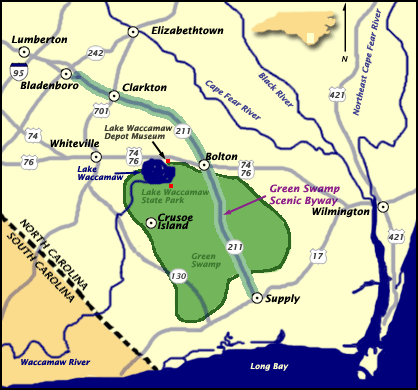
    The Nature Conservancy’s website is a great source for up to date information on trail conditions, they maintain 17,424 acres of long-leaf pine savannas and bogs in the Green Swamp. The trail head is off of 211. Southeast of 74, northwest of 17, in Brunswick county.

“The Green Swamp contains at least 14 different species of insectivorous plants, including extensive populations of Venus flytrap, sundew, butterworts and bladderworts, and four species of pitcher plant. The preserve is also home to many rare animals, including the American alligator, Henslow's sparrow, Bachman's sparrow, and Hessel's hairstreak butterfly.”

    
Photo from flickr
Today the Waccamaw Siouan tribal homeland is officially located on the edge of the Green swamp, 37 miles west of Wilmington, NC, but native people have lived in the land between the rivers of the coastal Carolinas for thousands of years. The Waccamaw, the Peedee, and the Cape Fear Indians all had settlements in the area at the time of the European invasion.

  
Giovanni da Verrazzano
 
An Italian explorer hired by the French looking for trade routes to China was believed to be the first European to visit the area when he landed at Cape Fear in 1524. He wrote that the area had white sandy beaches with high dunes and a plain to the west that contained forests with trees that he said defied description. He continued up the coast wrongly believing he’d discovered the route to China when he saw the vast sounds to the west of the Outer Banks.

    Just two years later the Spanish, who had established colonies to the south, landed at Cape Fear and attempted a short lived settlement. The Spanish continued to attempt northern expansion of their interests and failed repeatedly as they encountered struggles navigating the dangerous capes, faced resistance from the native people, and found traversing the swamps impossible. 
    
    
Richard Grenville
The area got its scary name in 1585 when Sir Richard Grenville’s expedition stranded on the cape’s shoals at low tide. As the crew watched the waves crashing from two directions they saw sharks frenzied over stranded schools. They were terrified their ship would break apart and they would have the same fate as the fish. After the high tide released them they decided the cape would be named Cape of Fear, in honor of their worst fears.

    The English had successfully established a colony in Virginia in 1606. They established a strong hold on the northeast, with the colonies of Maine, Plymouth, New Hampshire, Salem, Massachusetts Bay, New Scotland, Connecticut, New Haven, Maryland, and Rhode Island and Providence.
    
Irish Terror
The English Civil Wars from 1642 to 1646, again in 1668, total turmoil, and a temporary dictator, Oliver Cromwell, led to an influx of immigrants to the new colonies from Scotland, Ireland, and Wales. Though often debated as to how severe, there is no debate that Cromwell focused his attention on committing atrocities in Ireland in the name of English colonization. There were murders, forced evictions, and the deportation of over 50,000 people officially labeled prisoners of war or indentured servants. After Cromwell’s awful reign, King Charles II created the Carolina colony in 1663 and gave ownership to Lord Proprietors, who then divided it to be sold to English merchants interested in settling the new world. Many of the poor Scotch-Irish who had immigrated to the colonies to the north moved south into the mountain and Piedmont regions of Carolina.

    
NCPedia
The southern part of the Carolina Colony was already thriving, as planters with connections to established colonies in the West Indies created a robust economy centered around the port of Charleston. North of Cape Fear coastal settlement had proved to be more difficult. The many shipwrecks along the capes led to the nickname of the Graveyard of the Atlantic.The regions began their development in separate ways. Recognizing the geography was making trade difficult, the Lords created separate plans for further development and split the colony into north and south in 1710, with the Cape of Fear being the divider.

    Coastal plantations were benefiting from trade with England, as small subsistence farms dotted the land to the west. Acquiring slaves and participating in trade was difficult for inland farmers because of the vast swampy wilderness between them and the coast. There were political and social tensions between farmers and planters. The Lord Proprietors encouraged participation in the English mercantile system and slave trade. Plantations eventually spread out across the area, growing sweet potatoes, peanuts, indigo, rice, and tobacco.

    Thomas Smith was granted the land around the cape in 1713, which included soon to be Smith Island (Bald Head Island) and Smithville (Southport). The following year, Thomas James was granted 1000 acres west of the Cape Fear River.

    
Stede Bonnet
This was the Golden Age of Piracy and the British were battling pirates along the trade routes in the Caribbean and Atlantic. The Battle of the Cape Fear River between infamous pirate Stede Bonnet and British Naval Officer William Rhett bloodied the waters in September of 1718. Bonnet was captured and was subsequently hung in Charleston.

    In 1725, more land in the area was granted to Maurice Moore, Samuel Swann, Charles Harrison, and Eleazar Allen. Moore, a second generation planter who had defeated the Cape Fear Indians in battle, founded Brunswick Town in 1726 on the river just inland. (Just have to add that obviously the 'Cape Fear Indians' had a tribal identity not shaped by a white mans fear of dying shipwrecked on the coast he was 'conquering'.) In 1732 the town that would become Wilmington was founded further inland on the river. Near Brunswick Town in 1735 Moore built Orton plantation and began growing rice there.


     As global trade increased, the need for lumber and tar for boats increased, and interest in the vast Carolina wilderness increased. In 1735 the swamps were explored by popular naturalist William Bartram who published a book about his travels through the south. Soon the area began attracting development. The rivers became routes for the export of trees to the naval yards.

    In 1745 Spanish privateers were increasing attacks on English interests and a fort was built at the mouth of the Cape Fear River, Fort Johnston.
    Revolution against the British, technically began in 1776, but the war raged on for seven years. One of the last Revolutionary War campaigns in North Carolina was the Wilmington Campaign of 1781.
    Brunswick Town did not survive the revolution, though Orton plantation did and its owners eventually bought the land that had been Brunswick Town for pocket change.
    In 1792 the town of Smithville grew at the mouth of the Cape Fear River around Fort Johnston. The town was named after revolutionary war colonel, area planter, and eventual governor, Benjamin Smith. In 1795 Benjamin Rowell sold 25,000 acres of swampland west of Smithville to Smith for '2,000 pounds'.
    In 1797, the state sold close to two hundred thousand acres of the Green Swamp to planters Stephen Williams, Benjamin Rowell and William Collins for around $7,000. Some of the land was ditched and drained for farming.

In 1802 the senate first made a proposal for an Intercoastal Waterway (ICW) on the east coast from the Gulf of Mexico to Boston. The Great Dismal Swamp Canal on the VA/NC border opened in 1805, while the Army Corp of Engineers (ACOE) began work on other sections in 1824 with a goal of making the coastline more navigable. 
    
A lighthouse was built on Smith Island in 1817 to mark the mouth of the Cape Fear river. (For certain, I will write a future post about Old Baldy.)
    During the Civil War blockade runners defended the people and supported the struggling economies of the port and river towns. Many inland towns were battlefields. The thick swamps protected others from the wrath of Union soldiers. The tribes in the swamps and along the rivers welcomed runaway or freed slaves into their communities. A fort was built north of Cape Fear at the New Inlet. Fort Fisher, Fort Johnston, and Fort Caswell defended the area from the Union Army. Wilmington was one of a very few southern cities to escape destruction.
    During reconstruction, carpetbagging northern industrialists treated the south as the spoils of war. Owners of paper mills recognized the potential of the quick growing pines in the savannas and began buying acreage in the late 1800's.
    The Jim Crow era brought tense race relations. The white supremacy movement was angered by the success of freed slaves and other free people of color and began promoting discord between native populations and free slave populations. They also moved within political circles to create laws hindering non whites. People of color and poor whites in the coastal area were violently forcibly removed from the centers of commerce and positions of power. Under Jim Crow a separate second class developed in the south and created an economy of fishing and subsistence farming.
    

As the industrial revolution continued the poor people in the area began taking work in mills. Work conditions were not safe. Industrialists were unconcerned with the welfare of their employees or the impact they were having on the valuable natural resources they were utilizing.
    
After the first world war, amid the environmental destruction of the industrial revolution, a nostalgia for agrarian life led wealthy families back to the rural south. This southern renaissance led to renewed development on the coast. In the 1920’s the proposed development of “Palmetto Island” on Smith Island (BHI) resulted in clearing land to make way for roads, the building of a pier, a pavilion, and a hotel that was never completed.
    From 1929 to 1932 the ACOE completed a channel that cut across the Cape connecting the river and the Myrtle Grove Sound which has an inlet to the Atlantic. Snows Cut was named after the ACOE Major in charge of the project. The channel was span with a wooden drawbridge until 1931, then a steel swing bridge, which was replaced with the current high rise concrete structure in 1962.

Click here to learn more about the Dow ruins
 
The Ethyl-Dow plant was built in 1934 on the river banks between Snows Cut and Fort Fisher. The plant extracted bromine from seawater. During WWII it became an important military installation, one of many important area defense industry locations. The legend anyone from around the area will tell you is that the Nazis bombed the Dow plant. It was decommissioned and demolished but the brick and concrete ruins can still be found in the woods off of Dow Road between the towns of Carolina Beach and Kure Beach. (Future post on that place for certain!)
    In 1951, Sunny Point Military terminal became official as the largest east coast location for the transport and storage of munitions just across the river from the Dow site.


    Another wave of people moved to the coast as the spread of air conditioning made life in the humid swampland more hospitable. The post war era in American was marked with massive economic growth and a pop culture boom. 1960's Hollywood helped spur a global fascination with surfer beach culture, sending families and teenage boomers to the coast in droves. Real estate development of coastal areas became extremely lucrative.
Ocean Isle

    Some marshland on the west sides of the sandy barrier islands was canaled to create rows of vacation homes with dock access. 
Frank Sherrill had a development plan in place to fill and dredge thousands of acres of wetland and marsh on Smith island for development of a modern resort. There was to be high rise hotels, shopping, amusement rides, and a replica pirate ship in Buzzard Bay.
       Environmentalists discovered what the first explorers noted: that the cape fear area of NC was home to a complex range of flora and fauna. It was the boundary line between the temperate zone and the subtropical zone. There is some biology there that doesn’t exist anywhere else in the world, like the Venus flytrap. Fights between developers and environmentalists made the papers. 

        Preservation of the area began in 1969 when 761 acres of cypress swamp, old growth live oak and long leaf pines stands, and bogs full of carnivorous plants, along the Cape Fear River was preserved as Carolina Beach State Park. (Future post about camping there.) The area around the Green Swamp which was owned by paper producers was designated a national natural treasure. Smith Island was bought by Carolina Cape Fear Corporation, a group of outdoors-men from the Piedmont who planned responsible development and immediately gave 12,000 acres to the state for preservation, managed today by the Bald Head Island Conservancy and the North Carolina Nature Conservancy. (I could write a book about BHI, but I'll save the stories of that amazing island for future blog posts.)
   
In 1970 construction began on the Brunswick Nuclear Generating Station along the river just south of Orton Plantation beside Sunny Point, just north of Southport. This further fueled local speculation that Sunny Point had nuclear weapons. The power plant uses water intake from the river to cool it's reactors, and a drainage canal leads the hot water away through the area's wetlands and out into the ICW just south of Southport. There has always been some controversy as well as a great deal of urban legend surrounding the power plant.
    
    By the late 1970's environmentalists had created global awareness about the dangers of deforestation, promoting recycling, and painting the paper industry as wasteful tree killers. The companies rushed to save face. The Federal Paper Board donated their swampland to the state, creating the Green Swamp Preserve.
Today, 14,000 acres of land is protected, maintained by the Nature Conservancy, and they maintain trails where visitors can walk through the bogs and the savannas and observe the rare bug eating plants and if lucky the even scarier snapping jaws of the American alligator. 
    The trails are currently open, and social distancing is required.

Oak Hollow Camp Ground

  I haven't blogged in a while, I went down the ancestry research rabbit hole for a while and also have been working on home projects, f...