Click Here to see inside the Castle

Huntington Beach State Park, South Carolina ⛺🚌🚿🚽💧⚡🚙
A few years ago I decided I wanted to plan a camping trip alone. I have been traveling by myself as long as I could drive, but I'd never camped by myself. I was looking for a safe camping experience near the beach, somewhere with a lower latitude than home to get away from the coming winter.
I googled something like ‘images of beach camping SC’ and scrolled through looking for something that didn’t look too cheesy. Lots of pictures of RVs lined up like used car lots in Myrtle Beach. Not what I was looking for. Eventually a picture of a large live oak tree full of Spanish moss caught my eye. When I clicked on it, there was a picture of what looked like a fortress or a castle, with turquoise iron works over the windows. I thought it was in the Caribbean or the Mediterranean. I couldn't believe a place that beautiful was just a short drive south from the Cape Fear area of North Carolina where I was born. I also couldn't believe I'd never heard of it before. The pictures led me to South Carolina State Park’s website page for Huntington Beach.
 |
| (My image, ask for permission for use) |
Come with me on a virtual journey to explore this magic place.
The State Park is located in northeast Georgetown County South Carolina, and stretches between the Waccamaw River and the Atlantic Ocean just south of Murrells Inlet on highway 17. Where the Waccamaw joins the Little River and other tributaries in SC its depths increase and many plantation homes still line its banks. It continues parallel to the coast until it reaches Winyah Bay at Georgetown, emptying into the Atlantic. Murrells Inlet is about halfway between Myrtle Beach and Georgetown.
I've driven to Murrells Inlet several times to enjoy the seafood and inlet views. One time I decided to drive through to the end of the tiny fishing town to see what the next stop on 17 south looked like. After a few miles of what seemed like nothing but woods I gave up and turned around, not knowing the area and not wanting to drive all the way to Georgetown before I found civilization. Those woods are the state park!
I was definitely interested in exploring that geography, but when I began reading the history I really got intrigued.
Let's travel through time together!
Thousands of years ago nomadic people lived along the Waccamaw River. Archaeologists found Indian Burial Mounds along the banks west of Murrells Inlet. The area is called Wachesaw, which means ‘the place of great weeping.’ The Waccamaw Indians settled and built villages on the river's shores and on the Peedee River to the west. The Peedee People settled the land west of the river bearing their name. There is plenty of evidence of the civilization of indigenous people who lived in the area before the European Invasion.
The English came, spent decades ‘removing’ the native populations, and claimed the land for themselves, carving it up, creating land grants given to lord proprietors like Robert Daniel, who then subdivided their land and sold it to smaller individual planters, like Captain John Murrell. The plan was for these farmers to get established, and eventually start producing goods to enter into the English economy, specifically for SC, a trade partnership with their established sugar production in the West Indies. The land from the inlet to the Waccamaw belonged to the Murrell family for which the inlet is now named. They built a large home on the bluff around 1733. Murrell was just growing enough for himself and his family at first. At that time planters were experimenting with different crops.
Many early planters were farmers who may have had a few slaves, but worked the land and only raised enough for their plantation to subsist. They were not yet established in trade. Their homes were not necessarily lavish. Some plantations were owned by planters who lived elsewhere and never built a home on the land.
By the mid 1700's the global economy was becoming more established, with trade routes patrolled by navies and tariffs and taxes enforced with armies. The British had a stronghold in the new world. Planters began to come to the area with wealth and trade connections already in tow. These mercantile families built many large homes along the two rivers. They planted rice in the marshland, which was extremely labor intensive, requiring more slaves.
 |
| (I do not own this image, source: Google image search) |
In 1740 Eliza Lucas moved to SC from the island of Antigua, where her father had sugar cane plantations. She was just a teenager when she took over management of her family's three SC plantations. As she was accustomed to certain luxuries she spent her time at Wappoo, the plantation closest to Charleston, but they also had a plantation inland producing tar and timber, as well as several thousand acres of rice plantation along the Waccamaw river. Eliza’s father wanted her to come back to the island. She had no intention of giving up her control of the SC stake in her family holding and in order to stay in the colony, she married a family friend, much older widower Charles Pinckney, who owned a neighboring plantation. Ever independent and interested in botany, Eliza used seeds her father sent from Antigua to begin experimenting with crops, wanting to further diversify. She began planting indigo. Indigo is a plant used primarily as a dye, and a tropical plant that had previously failed to be hardy enough for Carolina’s moderate winters. Utilizing the techniques of the West African slaves for cultivation and dye production. Eliza succeeded where others had failed and a new agricultural export was introduced to the Carolina coast.
John Murrell and others began raising indigo as a cash crop.The area around Murrells inlet was divided into separate narrow properties running west to east from the river to the coast. Wachesaw, Richmond Hill, Laurel Hill, Springfield, Brookgreen, and the Oaks.
Although they were reliant on the British for trade many planters were fed up with British wars abroad, tariffs, and taxes making that trade more and more difficult. Planters in the area supported the efforts of the Revolution. They were just outside of the direct theater of the war, and most avoided the violence altogether.
After the Revolution, rice cultivation techniques improved, planters in the area concentrated on the more profitable crop and indigo became a stable back up for any interruptions in rice trade. Murrell passed his land to his children who divided it into the two plantations. Wachesaw was sold in 1800 while Richmond Hill stayed in the Murrell family until it was eventually sold to the Allstons, a very prominent, political family who acquired many of the state’s plantations. After a few generations of participation in the global economy, a vast amount of wealth and political power began to accumulate among the South Carolina rice planters.
 |
| (I do not own this image. Source: Google image search) |
Joshua John Ward was born at Brookgreen Plantation in 1800 and eventually became known as the king of the rice planters, and the largest slave holder in America.
Robert Allston, born in 1801 on one of the family's plantations along the Waccamaw, became the 67th governor of SC. He wrote about spending time at Murrells Inlet with his brother in law, John Tucker, and other planters when he was as young as 16. Tucker, Major Ward (JJ's daddy), and others had a good ole boys club at the inlet where they had been producing salt as a side interest. They used the club for hunting, fishing, and coming together for food and drinks.
The rice plantations flourished for a while. Their homes were extravagant, their personal physical appearance was often bloated and blushed from overindulgence. They most likely played more than they ever worked, as they had slaves doing the labor and less affluent whites running the daily plantation operations.They were living the life high on the hog as the expression goes. It was a good time to be in the rice business.
In the mid 1800's, feeling their cash crop threatened by talks of abolition of slavery, the rice planters, already heavily involved in politics, began discussing ways to circumvent the inevitable. They decided if SC left the union they could still have their slaves. We all know what happened after that.
Most of the rice plantations actually managed to escape the destruction of the Civil War, though some planters went away to fight never to return. Folks in the area say the war of northern aggression just couldn't make its way through those swamps. There was a small Confederate fort at Murrells inlet where blockade runners could stop and get supplies.
War didn’t destroy them, but the eventual economic changes left them in ruin. Rice production was extremely labor intensive and the planters no longer had slaves. The party was over. As the area’s economy began to shift to lumber inland and fishing closer to the coast, a new wave of working class European settlers moved in and some of the land was further divided into small parcels and sold off cheap by heirs of planters who’d left the area and didn’t want anything to do with the blood stained business of planting.
At the end of the 1800's several hurricanes devastated the area. Some of the plantation homes succumbed to the wilderness altogether, hidden forever in the kudzu. Fishing became the area's main economic driver, and tourism from city folks who had new found wealth from industrialization and a romanticized view of nature and the antebellum south. A group of outdoors men bought several plantations and used them as hunting grounds, others continued to struggle as farms into the 20th century only to wither and die during the Great Depression.
 |
| (Source: Google image) |
The Huntington's
It was during the Depression that ‘yankees’, Archer Huntington, and his artist wife, Anna, purchased Laurel Hill, Springfield, The Oaks, and Brookgreen with the intention of building a southern home where they could spend winters.
Archer was a wealthy scholar who studied poetry and Spanish language and culture. His father was a philanthropist, railroad magnate, industrialist. Anna Hyatt Huntington’s father was a Harvard zoology professor who encouraged her interest in animals and anatomy. She was one of the most famous American sculptures of the early 20th century. Together they had a lifelong commitment to philanthropy. The Huntington family created a legacy across the country that showcased their love of nature and the arts.
 |
| (Source: Google image) |
Anna was suffering from tuberculosis which was relieved by open air and a warm climate. Archer and Anna designed and built a home near the beach. They called it Atalaya, which means watchtower in Spanish. They hired almost entirely local craftsmen and in two years constructed a Moorish style castle.
There were indoor and outdoor sculpture studios, stables for all their animals, including bears, and many many rooms for the locally hired help. The pair had separate spaces for their personal interests and separate baths and closets. They had spaces for coming together to dine, but no rooms for entertaining or hosting guests. The home was their shared art project and was used as a place to get away from society, recharge, and create.Anna designed an elaborate garden for her large sculptures on the western part of the property. Brookgreen Gardens opened in 1932 as the first public sculpture garden in the country.
The couple allowed the military to use Atalaya during WWII. After Archer's death in 1955 Anna never returned to the house, spending her time up north at Brookgreen gardens or in Connecticut. The property was leased to the state for preservation as a park in 1960. Anna died in 1973 leaving a legacy that will last indefinitely.
My first trip to HBSP
I spent days down the rabbit hole of SC history websites and Wikipedia devouring the stories of native people and their place of great weeping, indigo cultivated by a female planter, rice planters gathering to hunt like porky the pig looking for wabbits, and yankee heirs of the gilded age who’d been privileged to spend their lives indulging their interests and giving away a dead industrialist’s fortune. I was determined to explore this place, so I went back to that first website, used their campground map and google earth to choose a campsite that was wooded and close to a beach access and bathrooms. (Now their website has pictures of each site, it's great!) I chose site number 13. I wasn’t sure about online reservations then, (turns out it’s super easy) when I called to reserve the site a few weeks ahead of time the lady on the other end of the phone told me I was very lucky to get this particular site at such short notice. (Later I discovered it often books up six months in advance.) I made a reservation for a few days in the middle of the week, the first week of December.
I wasn’t totally sure what to expect, I was car camping with my midsize SUV, I was going to a place I’d never been, and I was going to be by myself. I planned my trip meticulously and packed way ahead of time. The end of November I set out down the highway and made great time to my mom’s house in Wilmington, NC. Mama DJ and I met up with my goddaughter, had a great seafood dinner, at Hieronymus, and called it a night.
The next day I got up early, had coffee by the pool, and hit the road headed south on 17. Just across the state line I stopped for lunch in Little River, a tiny fishing town with a sandy little waterfront on a bluff above the Intercoastal Waterway. There are several restaurants there amongst the live oaks. I went to Key West Crazy’s, sat on the deck, and ate coconut shrimp washed down with margaritas. I planned on spending the night with my friends Randy and Lisa. They are retired boomers, and they are usually tons of fun; late nights dancing in the clubs, it's like hanging out with youngins! However, this particular time period was a rough one for all of us, I was going through the end of a long relationship and Randy had recently lost a good friend. It was immediately different than usual. Apparently, they had gone down an internet rabbit hole too, but theirs was conspiracy theory time and my friends were talking about chemtrails, pedophile islands, and a trans Mrs.Obama. It was all too much for me as I had come to the coast to clear my head, so when the subject turned to flat earth and simulated life I decided to leave. I called the campground hoping I could get my space a day early, nope, but they had one very close. I decided I’d risk it with a site unseen. I thanked my friends for the lovely conversation and got back on the road.
By two in the afternoon I was turning off of 17 at a small gate surrounded by tall trees, nothing else around for what seemed like miles. I followed the signs a short way through the trees to a guard house where I was waved along after saying, ‘I’m camping,’ seconds later there was an opening in the forest and I was driving across a low narrow bridge with marsh and tidal flats on either side of me. There were egrets and heron fishing in the flats.
It is a really breathtaking way to slow down and begin the readjustment to island time. Campers check in at the gift shop, where you can buy snacks, firewood, and tons of souvenirs. There are two giant wooden beach chairs painted tropical colors for photos, and a large playground is visible closer to the public beach access.
My campsite was in the older more wooded north campground, larger RVs need to go in the south campground. For my first night, it was site 19. A large, open site adjacent to a picnic shelter, much too large for what I needed, but I was determined and by four I had it set up. I backed my vehicle up to the only trees, popped open my trunk, hung up a couple tarps as walls, plugged in my extension cord, put up my lights,clicked in my car privacy curtains, pumped up an air mattress in the back of the car, and still had daylight to go exploring.
I walked along the road back up to the area where I had checked in and then I saw it! Not sure how I'd missed it before. Off in the distance was the castle.
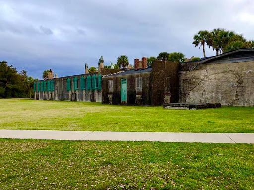
(This is my image, please ask for permission before use.)
It was closed for the evening but I was thrilled just walking around it, surrounded by palm trees and live oaks, its brick work is unfinished exposed mortar,and covered with ivy in places. Sitting on its large brick patio I could hear the waves. I walked along a sandy trail through the thick maritime forest and across the white fluffy dunes out onto the beach just in time to watch the sunset. Then I returned to my campsite, crawled into the back of my car and went to sleep early, eager to explore more in the morning.
 |
| (My Image) |
I woke before sunrise and made coffee. (I brought a coffee maker.) I walked to the closest beach access with my cup. The trail cut through the thick woods on a wooden boardwalk, crossed over a swamp, and exited the woods at the dunes. The beach was wide and empty, the sunrise was perfect. On my way back to camp I saw site 13 was already empty, I hurried and pulled down my tarps and moved to my new site.
Site 13 is very wooded and swampy. (I love swampy!) There is a large dry area, a fire ring, and a picnic table. I pulled the table closer to the fire ring and backed my car up. I ran extension cords, and hung tarps, tapestries, and lights. I put out rugs and even had an extra air mattress as an outside sofa. I was glamping!
 |
| (My image) |
It was warm for the first of December, reaching in the 70's that day and I took full advantage of the weather, spending the afternoon on the beach. I lost track of time and missed going into the castle, but undeterred I had a selfie shoot at magic hour before returning to my site to prepare for the rain. I hoisted a large tarp over the back of my car and the picnic table and made a fire.
After dinner it was again time to sleep. The next day I had to go to the castle! It was cooler and drizzling but I had a leather jacket over a hoodie and I was fine. There was a Christmas event going on in the castle and every room was filled with artists selling their things. In the indoor sculpture studio, there was a large Christmas tree, a choir singing, and a fire in the fireplace. In the horse stables there was hot food for sale, I had BarBQue. It started raining heavily. I walked from room to room reading in my brochure what each room had been and who the artist was inside it now.
The building itself is incredible. It is a large square like a fort, with a courtyard in the middle. The courtyard is beautiful, green grass, towering palm trees, ivy on the brick walls, windows with the signature iron designed by Anna and created by local blacksmiths. In the middle of the courtyard is the home’s namesake, a large tower which once held water for the estate. The structure has seen better days; most of the glass is out of the windows, and there are large cracks from foundation settling. It is still an impressive piece of architecture and history.
After I stuffed a few Christmas presents into my backpack, the rain had slowed so I walked the beach back to my site. I found a starfish and a sand dollar! I built a fire, cooked dinner and checked my phone to see what the weather looked like. Huge storm coming in, I’d be packing up in the rain if I waited much past noon.
Early to bed early to rise. I hoped to go see Brookgreen Gardens after I packed up, but the rain came as soon as I was done and it was torrential. I made my way slowly back to civilization, with a new favorite place and the determination to go back as soon as possible. And I have, a couple times, with the intention of returning annually for as long as possible. I’ll write another post about cold weather camping with Mama DJ and probably another about primitive camping with my twin sister.
Admission to the park is $8 for adults $4 for kids, free for campers. Campsites range from $25-30 a night for primitive sites to $50-70 for sites with hookups.The rates vary throughout the year. Once you’re inside Huntington Beach State Park you can go explore the interior of Atalaya for two bucks and enjoy its grounds for free, or soak up some nature on the beach, in the maritime forests, or along the marsh. There are miles of beautiful natural beach with a jetty at the far north end. The campground offers loads of amenities, bathrooms, showers, playgrounds, full hook ups and drive up camping. They also offer six ‘hike in’ primitive sites just a short walk of a few hundred feet into the woods.
For about $20 you can purchase a ticket to Brookgreen Gardens (across 17 from the state park.) that is good for a week. They offer eco tours, boat rides, plantation tours, a petting zoo, and endless gardens showcasing sculptures by many artists from around the world. Huntington Beach State Park and Brookgreen Gardens are truly a magical place that really stirs the imagination. I can't wait to go back!


No comments:
Post a Comment